Wisconsin wdnrwram natural wetland methodology print 2026

Get Form
wdnr wram Preview on Page 1

Here's how it works

01. Edit your wdnr wram online
Type text, add images, blackout confidential details, add comments, highlights and more.
02. Sign it in a few clicks
Draw your signature, type it, upload its image, or use your mobile device as a signature pad.
03. Share your form with others
Send wdnr wram natural resources via email, link, or fax. You can also download it, export it or print it out.

How to use or fill out Wisconsin WDNWRAM Natural Wetland Methodology Print

Form edit decoration
9.5
Ease of Setup
DocHub User Ratings on G2
9.0
Ease of Use
DocHub User Ratings on G2
  1. Click ‘Get Form’ to open it in the editor.
  2. Begin with the 'Wetland Identification' section. Fill in the project name, evaluator(s), file number, date of visit(s), and location details including PLSS, ecological landscape, latitude, longitude, watershed, and county.
  3. Proceed to 'Site Description'. Document soil types, wetland classifications, field verification status, wetland size, and impacted area.
  4. In 'Functional Value Assessment', assess potential human use values and wildlife habitat. Check applicable boxes and provide comments where necessary.
  5. Complete 'Floristic Integrity' by evaluating plant community integrity and listing dominant species. Use the provided scale for assessment.
  6. Fill out the 'Condition Assessment' section by identifying stressors affecting the wetland area and buffer. Provide a summary of your findings.
  7. Finally, summarize functional values and project impacts in their respective sections. Ensure all fields are completed accurately before saving your work.

Start using our platform today to streamline your document editing process for free!

be ready to get more

Complete this form in 5 minutes or less

Get form

Got questions?

We have answers to the most popular questions from our customers. If you can't find an answer to your question, please contact us.
Contact us

Yes, a typed name is recognized as a legitimate electronic signature when you add it to your document using a compliant solution like DocHub. Simply add your wi wram to our editor, click Sign in the top tool pane → Create your signature → Type your name in the appropriate tab, and select how it will appear on your document.

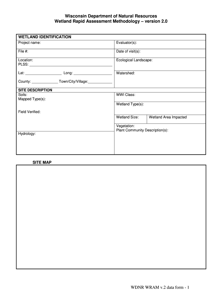
With DocHub, there are several convenient methods to edit your wisconsin wram online. You can drag and drop the form and modify it directly at the DocHub site or use our browser extension to fill out your form right away. On top of that, you can modify your PDF on your phone, as DocHub is compatible with all the available mobile platforms.

While better understood and no longer de- stroyed as rapidly as they were during Wisconsins first century of statehood, wetlands continue to be lost and degraded today. Only 53 percent, or 5.3 million acres, remain of the 10 million acres of wetlands present before statehood and many of those wetlands are in peril.
Wetlands are areas where water covers the soil, or is present either at or near the surface of the soil all year or for varying periods of time during the year, including during the growing season. What is a Wetland? | US EPA Environmental Protection Agency wetlands what-wetland Environmental Protection Agency wetlands what-wetland
Due to its diverse geography, geology, and climate, Wisconsin has a wide variety of wetland habitat types. Three primary factors influence a wetlands type: hydrology (the timing, frequency, and amount of water found on the site), soil type, and the plant life the site supports.

Security and compliance

At DocHub, your data security is our priority. We follow HIPAA, SOC2, GDPR, and other standards, so you can work on your documents with confidence.

Learn more
ccpa2
pci-dss
gdpr-compliance
hipaa
soc-compliance
be ready to get more

Complete this form in 5 minutes or less

Get form

People also ask

If your project is located in a wetland you will need to apply for an individual pond permit. *Please note: WAMS ID and password needed to apply. If you do not have a WAMS ID, you must register for one prior to proceeding. Ponds and Fish and Wildlife Habitat Structures | Waterway protection Wisconsin DNR - Wisconsin.gov Waterways construction p Wisconsin DNR - Wisconsin.gov Waterways construction p
For the most part, if a property has wetlands, you wont be able to build or develop in those areas without getting special permission from at least one (and often multiple) government authorities, and that permission wont be given unless you have a plan to mitigate the loss of those wetlands by buying wetland How to Identify (and Avoid) Wetlands - REtipster REtipster wetlands REtipster wetlands
The WRAM is a standardized process for wetland professionals to evaluate the extent to which a specific wetland performs a given function. The full range of wetland functions and values are covered. This qualitative method incorporates the evaluators best professional judgment and requires one or more field visits.
DNR authorizes wetland impacts through general permits and individual permits. Projects that meet the artificial exemption or the nonfederal exemption do not need a permit. Filling and converting wetlands to uplands are considered permanent impacts. Wisconsin Wetland Permitting Dashboard Wisconsin DNR - Wisconsin.gov topic Wetlands dashboard Wisconsin DNR - Wisconsin.gov topic Wetlands dashboard
Wetlands in Wisconsin were defined by the State Legislature in 1978: Wetland: An area where water is at, near or above the land surface long enough to be capable of supporting aquatic or hydrophytic (waterloving) vegetation and which has soils indicative of wet conditions.

wdnr wram natural resources