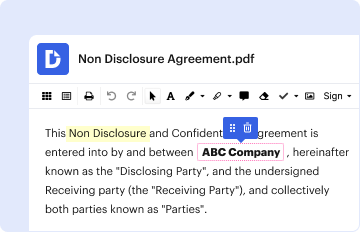
Type text, add images, blackout confidential details, add comments, highlights and more.
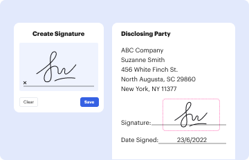
02. Sign it in a few clicks
Draw your signature, type it, upload its image, or use your mobile device as a signature pad.
03. Share your form with others
Send it via email, link, or fax. You can also download it, export it or print it out.
How to use or fill out Entry Form - OGRIP with our platform
Ease of Setup
DocHub User Ratings on G2
Ease of Use
DocHub User Ratings on G2
Click ‘Get Form’ to open the Entry Form - OGRIP in the editor.
Begin by entering the title of your map(s) in the designated field. This is essential for identifying your submission.
Indicate the number of maps in this series by filling in the corresponding field.
Provide the dimensions of your map by entering both height and width in their respective fields.
Select one category under which your map should be judged: General Reference, Communicative, or Analytical. Make sure to choose only one.
Fill in your name as the author, along with any organization details, phone numbers, and email addresses required.
Specify how you would like your participant and/or award certificate to read, including whether to include your organization name.
Confirm that you have read and understood the Rules & Guidelines by checking the appropriate box.
Once completed, email the form along with a PDF of your map (max 10MB) to ohiomapgallery@yahoo.com. You will receive a confirmation email upon receipt.
Start using our platform today for free to streamline your form completion process!
The study found that the most essential strength of the GIS is its effectiveness and efficiency, while its most important weaknesses are the lack of the GIS users experience and data unavailability and inaccessibility.
What are the limitations of GIS?
5 PROBLEMS WITH GIS IN REAL ESTATE. PROHIBITIVE COST. Smaller businesses and small government offices tend to think that they cant afford GIS. INCONSISTENCIES IN DATA. Your decisions are only as good as the data you use to make them. LACK OF STANDARDIZATION. SILOED GIS DATA. AREA LIMITATIONS.
What software is used for GIS?
The Major GIS Applications There are currently two major desktop GIS software applications (ArcGIS Pro and QGIS) that are widely used in academia, private industry, and the public sector.
What does ogrip stand for?
Ohio Geographically Referenced Information Program.
What are the three major criticisms of GIS?
GIS is a powerful tool, but critics emphasize its potential for misuse, data/ethical issues, and the risk of reinforcing biases. Ongoing debate encourages more thoughtful, ethical, and inclusive use of GIS technology in geography.
Related Searches
Entry form ogrip pdfEntry form ogrip onlineEntry form ogrip 2022Ohio gov entry form ogripEntry form ogrip ohioOSIP ogripOgrip lbrsOgrip rest services
A Geographic Information System (GIS) is a computer system that analyzes and displays geographically referenced information. It uses data that is attached to a unique location.
What are the disadvantages of a geographic information system?
However, GIS also has disadvantages, such as being very expensive software to acquire and requiring accurate data input to produce correct results. Additionally, non-GIS users may misuse the system and improper handling of layers can introduce errors.
Related links
Geospatial Data - Research Guides at Ohio State University
Aug 19, 2025 The Ohio GeoData Downloads site maintained by OGRIP provides access to datasets created through the Ohio Statewide Imagery Program (such as
This site uses cookies to enhance site navigation and personalize your experience.
By using this site you agree to our use of cookies as described in our Privacy Notice.
You can modify your selections by visiting our Cookie and Advertising Notice.... Read more...Read less