Type text, add images, blackout confidential details, add comments, highlights and more.
02. Sign it in a few clicks
Draw your signature, type it, upload its image, or use your mobile device as a signature pad.
03. Share your form with others
Send it via email, link, or fax. You can also download it, export it or print it out.
How to use or fill out landcan local-resourcesWalworth-CountyWalworth County Land Use and Resource Management Department
Ease of Setup
DocHub User Ratings on G2
Ease of Use
DocHub User Ratings on G2
Click ‘Get Form’ to open it in the editor.
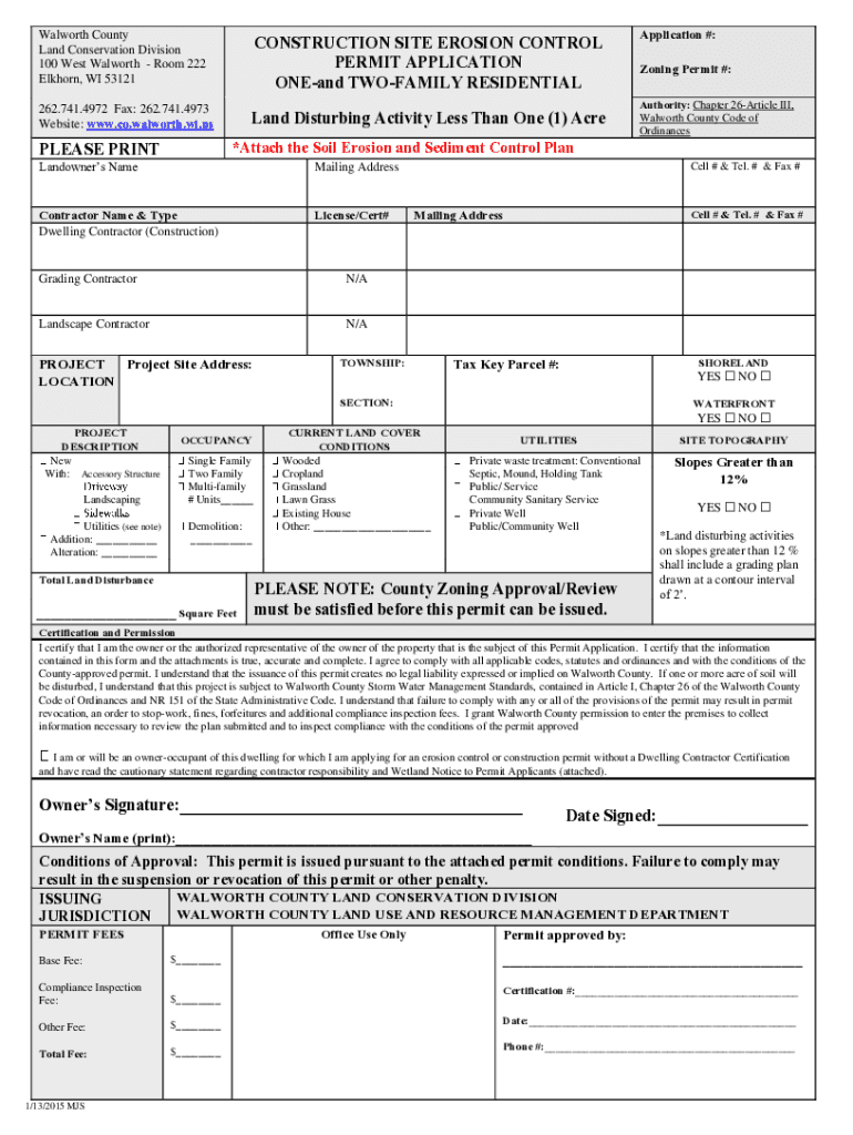
Begin by filling in the Landowner’s Name and Mailing Address. Ensure that all information is printed clearly.
Next, provide details about the Contractor, including their name and license number. Select the type of contractor relevant to your project.
Fill in the Project Site Address and any applicable Application or Zoning Permit numbers. This information is crucial for processing your application.
Indicate whether your project involves shoreland or waterfront areas by checking 'YES' or 'NO'.
In the Project Description section, specify if it's a new construction, addition, or alteration. Include details about occupancy type and total land disturbance.
Complete the Current Land Cover Conditions by selecting from options like Wooded, Cropland, etc., ensuring accurate representation of your site.
Finally, review all sections for accuracy before signing and dating the certification at the bottom of the form.
Start using our platform today to streamline your permit application process for free!
Fill out landcan local-resourcesWalworth-CountyWalworth County Land Use and Resource Management Department online It's free
See more landcan local-resourcesWalworth-CountyWalworth County Land Use and Resource Management Department versions
We've got more versions of the landcan local-resourcesWalworth-CountyWalworth County Land Use and Resource Management Department form. Select the right landcan local-resourcesWalworth-CountyWalworth County Land Use and Resource Management Department version from the list and start editing it straight away!
Agricultural zoning in California can vary docHubly by county, with some areas categorizing zoning more narrowly to regulate different types of farming. For instance, there might be distinct zoning ordinances for field crop production, livestock management, or specialized operations, such as vineyards or orchards.
What is the Stafford county land use program?
The Land Use Program allows for agricultural, horticultural and forest land to be assessed at use value, rather than its market value. The program was implemented to encourage land preservation and the protection of agricultural and rural land, while promoting proper land use planning and orderly development.
What is c4 zoning in Walworth County?
C-4 Shoreland Wetland District The primary purpose of this district is to preserve, protect, and enhance the lakes, streams, and wetland areas in Walworth County.
What is the Loudoun county land use program?
Owners of land in the Land Use Assessment Program may defer some of their real estate taxes on land used for agriculture, horticulture, forestry, or open space. Taxes due are based on the use of the land, with remaining taxes deferred, as long as the property remains eligible.
What is C6 zoning?
C-6 - GENERAL COMMERCIAL DISTRICT. The C-6 District is intended to serve as sites for the many uses in the commercial classifications which do not belong in either the Neighborhood, Community or Central Trading District.
Related Searches
Walworth County Zoning mapWalworth County Zoning OrdinanceWalworth County building Permits onlineWalworth County LURMWalworth county formsVillage of genoa city zoning mapWalworth County resourcesWalworth county land conservation department
Security and compliance
At DocHub, your data security is our priority. We follow HIPAA, SOC2, GDPR, and other standards, so you can work on your documents with confidence.
Zoning is the set of regulations that lists allowable uses and design requirements. Zoning also describes the review and approval process for your proposed use. Some of the Countys zoning categories are agricultural, residential, commercial, and industrial. Every property in the County has a specific zone.
What is B4 zoning in Wisconsin?
The B-4 General Business District is intended to provide for the orderly and attractive grouping at appropriate locations along federal, state, and county highway routes of those businesses and services which are logically related to and dependent upon highway traffic or which are specifically designed to serve the
Cookie consent notice
This site uses cookies to enhance site navigation and personalize your experience.
By using this site you agree to our use of cookies as described in our Privacy Notice.
You can modify your selections by visiting our Cookie and Advertising Notice.