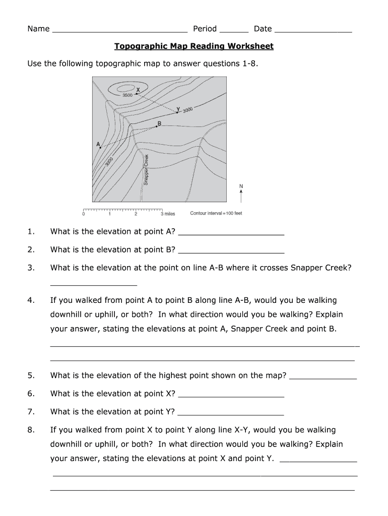


Understanding Topographic Maps
Topographic maps are essential tools that provide detailed information about the Earth's surface. These maps use contour lines, symbols, and colors to represent terrain features, allowing users to visualize elevation changes and the layout of various landforms. In educational settings, practicing with topographic maps enhances students' geographical skills and improves their ability to interpret physical landscapes.
Key Features of Topographic Maps
- Contour Lines: These lines connect points of equal elevation. Close lines indicate steep terrain, while spaced-out lines represent gentle slopes.
- Scale: The scale allows users to interpret distances accurately, showing the relationship between map units and actual ground distances.
- Symbols: Various symbols denote features such as roads, trails, rivers, and buildings. Familiarity with these symbols is crucial for proper map reading.
Importance of Topographic Map Reading Worksheets
Topographic map reading worksheets, especially those available as answer key PDFs, are valuable educational resources aimed at students. They guide learners through questions and exercises related to topography, effectively developing their navigation and map interpretation skills.
- Skill Development: Worksheets help students understand key concepts, such as calculating elevation differences and identifying geographical features.
- Practice & Reinforcement: These resources provide repeated exposure to reading and interpreting maps, which reinforces learning.
Utilizing Topographic Map Reading Worksheets
Components of a Topographic Map Worksheet
A typical topographic map reading worksheet may consist of:
- Questions: These are designed to assess comprehension of the map. For example, students might be asked to identify the elevation of specific landmarks.
- Scenarios: Real-world situations where students must apply their knowledge, such as finding the best hiking trail based on elevation gain.
- Visual Interpretations: Students may be required to interpret maps with varying contour line densities.
Answer Keys for Topographic Map Worksheets
Accessing a topographic map reading worksheet answer key PDF is important for educators and students alike:
- For Educators: Answer keys assist teachers in grading and providing feedback quickly.
- For Students: They serve as a self-check mechanism, allowing learners to verify their answers and understand their mistakes.
Practical Applications of Topographic Maps
Real-World Use Cases for Topographical Information
Topographic maps have various applications outside of the classroom:
- Hiking & Outdoor Activities: Hikers and outdoor enthusiasts utilize these maps for route planning, ensuring they understand elevations and terrain.
- Civil Engineering: Engineers refer to topographic data for construction and land development projects, as the maps indicate natural boundaries and landscape changes.
- Environmental Studies: Researchers study topography to assess ecological changes and understand geographic phenomena.
Skills Developed through Topographic Map Analysis
Engaging with topographic maps through worksheets fosters several skills:
- Analytical Thinking: Interpreting map data requires critical thinking and problem-solving abilities.
- Spatial Awareness: Students develop a better understanding of geographical relationships and spatial reasoning.
- Data Interpretation: The ability to read and extract information from maps enhances overall data literacy.
Conclusion on Topographic Map Literacy
Mastering topographic map reading is a foundational skill with broad applications in education, outdoor activities, and professional fields. By utilizing resources like topographic map reading worksheets and their corresponding answer keys in PDF format, students can deepen their understanding, improve their map-reading abilities, and appreciate the landscapes around them.