01. Edit your brevard county planning and zoning online
Type text, add images, blackout confidential details, add comments, highlights and more.
02. Sign it in a few clicks
Draw your signature, type it, upload its image, or use your mobile device as a signature pad.
03. Share your form with others
Send brevard county zoning map via email, link, or fax. You can also download it, export it or print it out.
How to use or fill out brevard county zoning map with our platform
Ease of Setup
DocHub User Ratings on G2
Ease of Use
DocHub User Ratings on G2
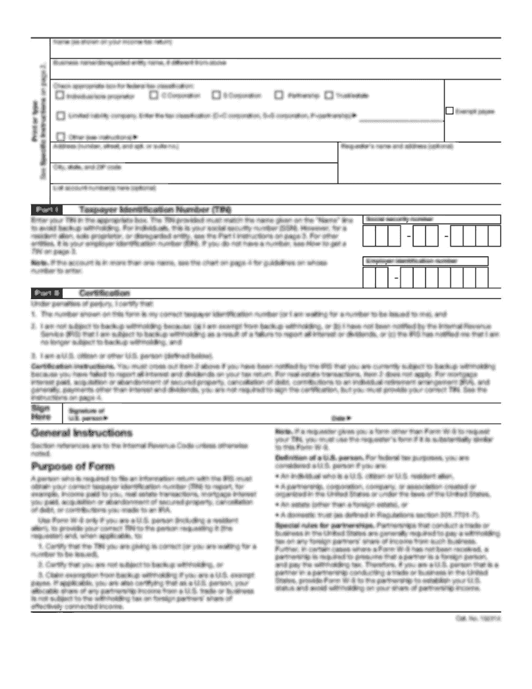
Click ‘Get Form’ to open the Brevard County Zoning Map in the editor.
Begin by filling in the 'Existing FLU' and 'Existing Zoning' fields. These are crucial for identifying the current land use and zoning classifications.
Next, specify the 'Proposed FLU' and 'Proposed Zoning'. This section allows you to indicate any changes you wish to make.
Select the appropriate application type from the options provided, such as 'Combination - Comprehensive Plan and Rezoning' or 'Variance'.
Fill in your Tax Parcel information, including T, R, S, S/D, Blk/Par, and Lot numbers. This helps in accurately identifying your property.
Provide a detailed description of your request in the designated area. Be clear about your intentions to ensure proper processing.
Complete the property owner and applicant sections with accurate contact details. Ensure that all signatures are obtained where necessary.
Start using our platform today for free to streamline your zoning application process!
Fill out brevard county zoning map online It's free
We've got more versions of the brevard county zoning map form. Select the right brevard county zoning map version from the list and start editing it straight away!
The B-2, Neighborhood Business-Arterial District is intended to provide areas of limited size along arterial streets in proximity to low density residential areas for a limited range of basic commercial trade and personal services. This district is also intended to provide areas for new high density residential uses.
What zone am I in Brevard County?
Most of Brevard County is in Zone 9B. Part of northern Brevard borders on Zone 9A and Zone 10 conditions exist in the southern parts of our barrier islands. Always select plants rated hardy for your zone.
What is bu2 zoning in Brevard County?
The BU-2 retail, warehousing and wholesale commercial zoning classification encompasses lands devoted to general retail and wholesale business, contracting and heavy repair services and warehousing activities.
What is rr1 zoning in Brevard County?
The RR-1 rural residential zoning classification encompasses lands devoted to single-family residential development of spacious character, together with such accessory uses as may be necessary or are normally compatible with residential surroundings, and at the same time permits uses which are conducted in such a way
How do I find the zoning of my property in Brevard County?
THE OFFICIAL VERSION OF THE UNINCORPORATED BREVARD COUNTY ZONING MAP AND FUTURE LAND USE MAP CAN ONLY BE VIEWED DURING REGULAR BUSINESS HOURS AT THE BREVARD COUNTY PLANNING AND ZONING OFFICE, 321-633-2069, 2725 JUDGE FRAN JAMIESON WAY, BLDG A-114, VIERA, FLORIDA 32940.
brevard county zoning
Brevard county zoning map pdfBrevard County zoning codesBrevard County municodeBrevard County Future land use MapBrevard County gis MapBrevard County Property AppraiserBrevard County mapsPalm Bay zoning map
Security and compliance
At DocHub, your data security is our priority. We follow HIPAA, SOC2, GDPR, and other standards, so you can work on your documents with confidence.
Cover: The plume maps represent the distribution of TCE in one groundwater zone at the MEW Superfund site in California, before and after 17 years of applying.
appendix b. crucial habitat ordinance (brevard county, fl)
Crucial Habitat Overlay Zone (CHOZ) - an area delineated on a map entitled the Brevard. County Crucial Habitat Overlay Map adopted by the Board of County
Map of service areas served by Utility Services Department in Brevard County. Zoning Future Land Use Web Experience. Zoning and Future Land Use Interactive
Cookie consent notice
This site uses cookies to enhance site navigation and personalize your experience.
By using this site you agree to our use of cookies as described in our Privacy Notice.
You can modify your selections by visiting our Cookie and Advertising Notice.