Type text, add images, blackout confidential details, add comments, highlights and more.
02. Sign it in a few clicks
Draw your signature, type it, upload its image, or use your mobile device as a signature pad.
03. Share your form with others
Send it via email, link, or fax. You can also download it, export it or print it out.
How to use or fill out Yellowhead Hwy, P with our platform
Ease of Setup
DocHub User Ratings on G2
Ease of Use
DocHub User Ratings on G2
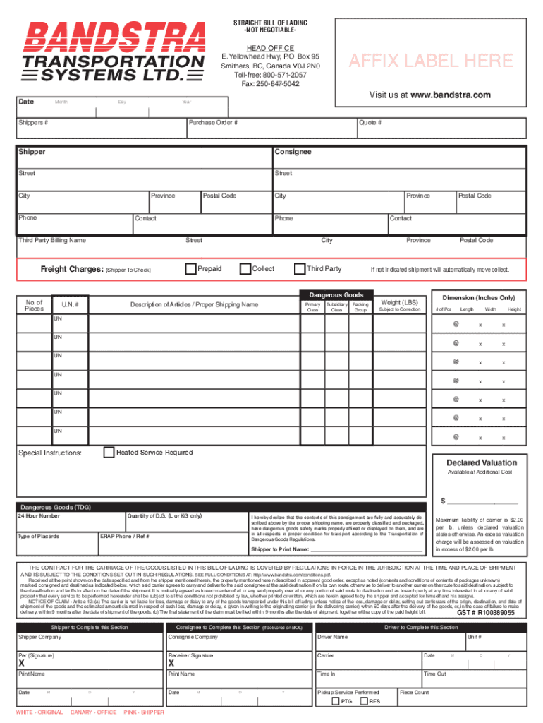
Click ‘Get Form’ to open the Yellowhead Hwy, P document in the editor.
Begin by entering the date at the top of the form. Ensure you fill in the month, day, and year accurately.
In the Shipper section, provide your company name and address details including street, city, province, and postal code.
Next, fill out the Consignee section with the recipient's information. Include their name, address, and contact number.
If applicable, complete the Third Party Billing section with relevant details for billing purposes.
In the Dangerous Goods section, indicate if your shipment contains hazardous materials and provide necessary details such as UN number and description.
Finally, review all entries for accuracy before signing. Use our platform’s tools to save or print your completed form.
Start using our platform today to streamline your document editing and form completion!
Regardless of how you go about driving the Yellowhead Highway, youll find the scenery and points of interest well worth the time. Some travelers skip it because it seems to be a road to nowhere.
Why is Highway 16 called the Yellowhead?
The highway is named for the Yellowhead Pass, the route chosen to cross the Canadian Rockies. The pass and the highway are named after a fur trader and explorer named Pierre Bostonais. He had yellow streaks in his hair, and was nicknamed Tte Jaune (Yellowhead).
Where does the Yellowhead Highway start and end?
From Prince Rupert, the Yellowhead route crosses the western provinces of BC, Alberta and Saskatchewan before officially ending in Winnipeg, Manitoba. The entire length of the Highway is numbered Highway 16 and is part of the Trans Canada Highway System (Not to be confused with the southern Trans Canada Highway #1).
What is the highest point on the Yellowhead Highway?
Obed Summit (el. 1,163.9 m or 3,819 ft), is a highway summit in Alberta, Canada. It is the highest point on the Yellowhead Highway, 33 m (108 ft) higher than Yellowhead Pass on the Continental Divide of the Americas of the Canadian Rockies on the Alberta / British Columbia border.
SPS-9A Construction Report, Yellow Head Highway Westbound, Radisson, Saskatchewan, Sections 900901 to 900903 and 900959 to 900962, FHWA, Pavement Performance
Cookie consent notice
This site uses cookies to enhance site navigation and personalize your experience.
By using this site you agree to our use of cookies as described in our Privacy Notice.
You can modify your selections by visiting our Cookie and Advertising Notice.