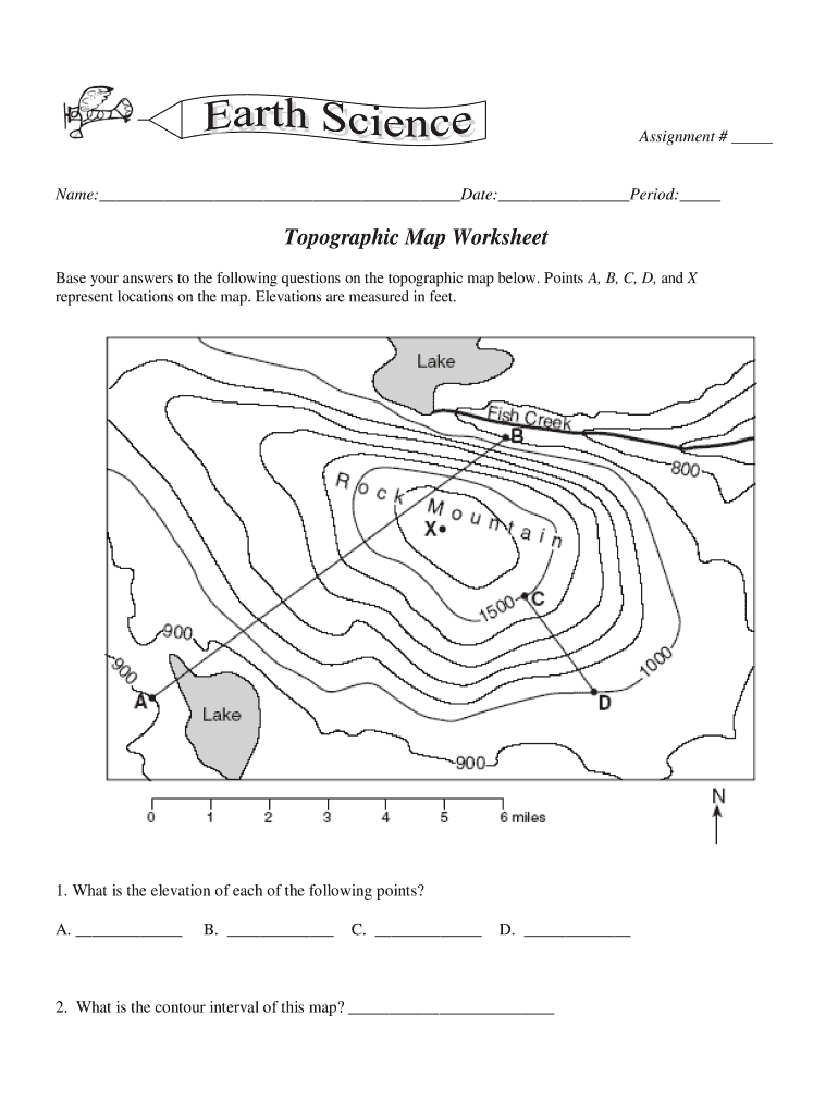


Definition and Meaning of Topographic Maps Worksheet
A topographic maps worksheet, particularly for eighth-grade students, is an educational resource designed to enhance students' understanding of topographic maps. Such worksheets typically include elements like contour lines, elevation markers, and geographic features, enabling learners to interpret landforms, measure distances, and analyze terrain. Topographic maps are vital in various fields, including geography, environmental science, and urban planning, providing a visual representation of the Earth's surface that showcases relief, slopes, and land usage.
Core Components of Topographic Maps
- Contour Lines: These lines connect points of equal elevation and indicate the shape of the land. Closely spaced lines suggest steep terrain, while widely spaced lines indicate gentle slopes.
- Elevation Markers: Specific points on a topographic map are marked with elevation values, providing insight into how high or low a particular area is.
- Land Features: A topographic map may display rivers, roads, buildings, and vegetation, helping students understand the relationship between human-made features and natural terrain.
How to Use the Topographic Maps Worksheet 8th Grade PDF
Using the topographic maps worksheet designed for eighth graders involves several steps to maximize learning and comprehension of geographic principles.
- Download and Print: Obtain the topographic maps worksheet in PDF format and print it for hands-on interaction.
- Familiarization with Symbols: Students should begin by reviewing the key or legend, which explains the symbols used on the map, including contour lines and elevation markers.
- Analyzing Contour Lines:
- Identify patterns formed by contour lines to determine slope steepness.
- Practice drawing imaginary lines through points of equal elevation to visualize landforms.
- Completing Exercises: The worksheet may contain questions or activities, such as calculating vertical drop, identifying high and low points, or estimating the distance between two locations on the map.
Steps to Complete the Topographic Maps Worksheet
Completing the topographic maps worksheet involves a systematic approach to ensure thorough learning.
-
Read Instructions Carefully: Each section may have specific guidelines that are crucial for accurate completion.
-
Utilize Reference Materials: If possible, consult additional resources such as geography textbooks or online materials related to topographic maps for better understanding.
-
Engage with Exercises:
- For gradient calculations, students should use the elevation difference between two points and apply the formula: [ \text{Gradient} = \frac{\text{Elevation Change}}{\text{Horizontal Distance}} ]
- Create topographic profiles by plotting elevation values on a graph.
-
Review Answers: Once completed, cross-check the answers using the provided answer key typically included with the worksheet, which aids in self-assessment.
Important Terms Related to Topographic Maps Worksheet
To effectively utilize a topographic maps worksheet, understanding specific terminologies is essential.
- Elevation: The height above a specified reference point, usually sea level.
- Topography: The arrangement of natural and artificial physical features of an area.
- Gradient: The degree of steepness of a slope, often calculated using elevation changes.
- Relief: The difference in elevation between the highest and lowest points in a given area.
Examples of Using the Topographic Maps Worksheet 8th Grade PDF
Real-life applications of the topographic maps worksheet can offer students insight into practical uses of geographic analysis.
- Environmental Studies: Students might analyze the impact of geographical features on ecosystems, discussing how elevation affects climate and vegetation.
- Urban Planning: Understanding the layout of land can help students appreciate how communities design infrastructure while considering natural landforms.
- Outdoor Recreation: Lessons can include discussions on how hikers and campers use topographic maps for navigation and identifying terrain challenges.
Key Elements of the Topographic Maps Worksheet 8th Grade PDF
A well-structured topographic maps worksheet includes several essential elements that facilitate effective learning.
- Clear Instructions: Directions should be concise and easy to follow.
- Illustrative Examples: Examples showing completed sections provide a model for students.
- Varied Activities: A mix of questions ranging from computational exercises to open-ended questions encourages critical thinking.
- Answer Key: An accompanying answer key enables self-assessment and feedback.
Who Typically Uses the Topographic Maps Worksheet 8th Grade PDF
The primary users of the topographic maps worksheet at the eighth-grade level are:
- Students: Primarily those in Earth Science or Geography classes focused on developing spatial reasoning skills through map reading.
- Teachers: Educators utilize these worksheets to assess student understanding and introduce basic map-reading skills.
- Homeschoolers: Families teaching geography to their children at home often employ these resources for structured learning.
By thoroughly engaging with the provided content and utilizing the topographic maps worksheet, students will enhance their understanding of topographic features and map interpretation, valuable skills not only academically but for future real-world applications.