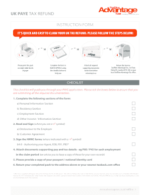
Flood Zone Statement and Authorization - New York 2025

Get Form
Flood Zone Statement and Authorization - New York Preview on Page 1

Here's how it works

01. Edit your form online
Type text, add images, blackout confidential details, add comments, highlights and more.
02. Sign it in a few clicks
Draw your signature, type it, upload its image, or use your mobile device as a signature pad.
03. Share your form with others
Send it via email, link, or fax. You can also download it, export it or print it out.

How to change Flood Zone Statement and Authorization - New York online

Form edit decoration
9.5
Ease of Setup
DocHub User Ratings on G2
9.0
Ease of Use
DocHub User Ratings on G2

With DocHub, making adjustments to your paperwork requires only a few simple clicks. Make these fast steps to change the PDF Flood Zone Statement and Authorization - New York online for free:

  1. Sign up and log in to your account. Log in to the editor with your credentials or click on Create free account to examine the tool’s functionality.
  2. Add the Flood Zone Statement and Authorization - New York for editing. Click on the New Document button above, then drag and drop the file to the upload area, import it from the cloud, or via a link.
  3. Adjust your template. Make any adjustments required: add text and photos to your Flood Zone Statement and Authorization - New York, highlight important details, remove sections of content and substitute them with new ones, and add symbols, checkmarks, and fields for filling out.
  4. Finish redacting the template. Save the updated document on your device, export it to the cloud, print it right from the editor, or share it with all the people involved.

Our editor is super easy to use and efficient. Try it now!

be ready to get more

Complete this form in 5 minutes or less

Get form

Got questions?

We have answers to the most popular questions from our customers. If you can't find an answer to your question, please contact us.
Contact us
231-B, effective June 21, 2023, requires every residential lease disclose any prior flood damage to the leased premises due to a natural flood event, such as heavy rainfall, coastal storm surge, tidal inundation, or river overflow, that the landlord knows or reasonably should know has occurred to such premises and the
You can also see crucial information on wind, fire and flood insurance requirements. If youre searching for homes on Zillows interactive map, you have the option to explore climate risk data for the area by clicking on the map options icon and selecting the risk category you want to see.
Special Flood Hazard Areas (SFHAs) are the areas that are at the greatest risk of flooding, mudflow, or flood-related erosion. High risk areas are started by either A or V, low and moderate flood risk areas begin with B, C, or X. D labels undetermined flood zones, where flood risk exists but is unmeasured.
There are a few options. FEMAs Region II Coastal site. Center for New York City Neighborhoods (CNYCN) FloodHelpNY.org. View the flood maps in person at the borough Department of Buildings offices: Bronx Borough Office - Theresa Hall. NYC Department of Buildings. 1932 Arthur Avenue, 5th Floor. Bronx, NY 10457.
While its true that Flood Zone AE is considered a high-risk area, with a 1% annual chance of flooding and a 26% chance over a 30-year mortgage, its not necessarily a deal-breaker. Heres why: Awareness and Preparedness: Properties in higher risk flood zones like AE are often more prepared.
be ready to get more

Complete this form in 5 minutes or less

Get form

People also ask

These zones range from high- to moderate-risk areas: VE, AE, AO, A, and X. While the flood zones identify the extent of flood risk, the Base Flood Elevation identifies the expect height that flood waters are expected to reach in a high risk area.
depending on area, google will often show flood information visually on the map during big flood events.
A Policy Declaration page is acceptable evidence of flood insurance.

Related links