Type text, add images, blackout confidential details, add comments, highlights and more.
02. Sign it in a few clicks
Draw your signature, type it, upload its image, or use your mobile device as a signature pad.
03. Share your form with others
Send it via email, link, or fax. You can also download it, export it or print it out.
How to use or fill out SAS APPENDIX 1: Request for Corps of Engineers Jurisdictional
Ease of Setup
DocHub User Ratings on G2
Ease of Use
DocHub User Ratings on G2
Click ‘Get Form’ to open it in the editor.
Begin by checking the applicable reasons for your request in Section I. You can select multiple options that describe your project intentions regarding aquatic resources.
In Section II, specify what you are requesting from the U.S. Army Corps of Engineers. Choose between Delineation Review, Preliminary Jurisdictional Determination, or Approved Jurisdictional Determination based on your needs.
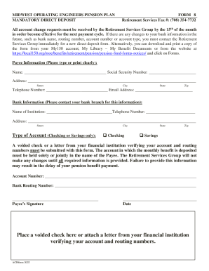
Complete Section III with property and owner information. Fill in the parcel number, address, and geographic coordinates (longitude and latitude). Ensure all fields are accurately filled out.
Provide details for both the landowner and authorized agent in Section 2. Include names, company affiliations, email addresses, and contact information.
Finally, review the property access permission section. Initial one option to confirm your authority over the property and sign with the date to complete your request.
Start using our platform today to easily fill out your SAS APPENDIX 1 form for free!
Fill out SAS APPENDIX 1: Request for Corps of Engineers Jurisdictional online It's free
An approved JD is an official Corps determination that jurisdictional waters of the United States are either present or absent on a particular site. An approved JD is valid for five years and can be appealed through the Corps administrative appeal process set out at 33 CFR Part 331.
What is the jurisdictional determination of the Army Corps of Engineers?
A Jurisdictional Determination (JD) is a two step process of 1) identifying and locating aquatic resources (including wetlands) on a property, which is referred to as a Delineation, and 2) determining whether those areas are regulated by the U.S. Army Corps of Engineers under section 404 of the Clean Water Act and/or
How long is a jurisdictional determination good for?
Each written verification is valid for a period of five years. The wetland delineation verification process is known as a Corps of Engineers jurisdictional determination (JD).
What is an approved jurisdictional determination?
Requests for assistance must be in the form of a letter that includes the location and problem to be investigated, submitted by a state, local government agency, U.S. Territory, federally-recognized Tribal Nation, or other non-federal entity to the appropriate USACE district.
What are the jurisdictional waters of the Army Corps of Engineers?
The U.S. Army Corps of Engineers is responsible for protecting many of the nations aquatic environments including oceans, rivers, lakes, streams, ponds, and wetlands. These areas are referred to by the Corps as waters of the United States.
Related Searches
Sas appendix 1 request for corps of engineers jurisdictional formSas appendix 1 request for corps of engineers jurisdictional letterSas appendix 1 request for corps of engineers jurisdictional 2022Sas appendix 1 request for corps of engineers jurisdictional 2021Sas appendix 1 request for corps of engineers jurisdictional quiUSACE Jurisdictional Determination mapUSACE jurisdictional Determination formUsace savannah District regional Conditions
Security and compliance
At DocHub, your data security is our priority. We follow HIPAA, SOC2, GDPR, and other standards, so you can work on your documents with confidence.
Feb 17, 2020 Attachment 1: SAS Appendix 1: Request for Corps of Engineers Jurisdictional Determination and/or Delineation. Review. . Request for CorpsRead more
33 CFR 222.6 - National Program for Inspection of Non
This regulation states objectives, assigns responsibilities and prescribes procedures for implementation of a National Program for Inspection of Non-FederalRead more
All downloadable National Academies titles are free to be used for personal and/or non-commercial academic use. Users may also freely post links to ourRead more
Cookie consent notice
This site uses cookies to enhance site navigation and personalize your experience.
By using this site you agree to our use of cookies as described in our Privacy Notice.
You can modify your selections by visiting our Cookie and Advertising Notice.