Type text, add images, blackout confidential details, add comments, highlights and more.
02. Sign it in a few clicks
Draw your signature, type it, upload its image, or use your mobile device as a signature pad.
03. Share your form with others
Send it via email, link, or fax. You can also download it, export it or print it out.
How to rapidly redact Flood Plain Information Request Form online
Ease of Setup
DocHub User Ratings on G2
Ease of Use
DocHub User Ratings on G2
Dochub is the greatest editor for changing your documents online. Adhere to this straightforward guideline edit Flood Plain Information Request Form in PDF format online free of charge:
Sign up and log in. Register for a free account, set a strong password, and proceed with email verification to start managing your templates.
Add a document. Click on New Document and choose the file importing option: upload Flood Plain Information Request Form from your device, the cloud, or a protected link.
Make adjustments to the template. Utilize the upper and left-side panel tools to change Flood Plain Information Request Form. Insert and customize text, images, and fillable areas, whiteout unnecessary details, highlight the significant ones, and provide comments on your updates.
Get your paperwork completed. Send the sample to other people via email, create a link for quicker document sharing, export the template to the cloud, or save it on your device in the current version or with Audit Trail included.
Explore all the benefits of our editor today!
Fill out Flood Plain Information Request Form online It's free
A floodplain (or floodplain) is a generally flat area of land next to a river or stream. It stretches from the banks of the river to the outer edges of the valley. A floodplain consists of two parts. The first is the main channel of the river itself, called the floodway.
What are the indicators of a flood?
Flood hazard indicators: a elevation, b surface slope, c drainage density, d distance to rivers, e rainfall, f soil type, and g flow accumulation.
What is the purpose of a standard flood hazard determination form?
The Standard Flood Hazard Determination Form is required for all federally backed loans and is used by lenders to determine the flood risk for their building loans. The form is authorized by the National Flood Insurance Reform Act of 1994 and is imposed on lenders by their regulatory entities, not by FEMA.
How do flood plains form?
Formation. Most floodplains are formed by deposition on the inside of river meanders and by overbank flow. Wherever the river meanders, the flowing water erodes the river bank on the outside of the meander. At the same time, sediments are simultaneously deposited in a bar on the inside of the meander.
What exactly is a floodplain?
The Federal Emergency Management Administration (FEMA) defines a floodplain as any land area susceptible to being inundated by floodwaters from any source.
Related Searches
fema form ff-206-fy-22-152FEMA Elevation Certificate form 2024FEMA Elevation Certificate form 2023 PDFA Standard Flood Hazard Determination form is good for how many yearsStandard Flood Hazard Determination Form 2024fema form 086-0-33FEMA flood Certificate PDFFEMA Elevation Certificate form 2025
Related forms
Print Form Submit by Email Departmental Program Assessment PHASE 3 Instructions for Completion HCC P
Floodplains are areas that are prone to being inundated by floodwaters during times of heavy rain, snowmelt, or high tides.
What best describes the floodplain?
Floodplains are land areas adjacent to rivers and streams that are subject to recurring inundation.
How to identify flood prone areas?
Which areas are a flood risk: Low-lying areas such as floodplains and coastal regions. Areas near rivers, lakes, and coastal regions. Areas prone to heavy rainfall, snowfall, and tropical cyclones. Areas with limited natural drainage due to urbanisation and infrastructure. Impermeable soil or soil with poor drainage.
Related links
How to Request a Map Amendment
Fill. Letter of Map Amendment (LOMA) is for when a flood map shows a building in the floodplain but it is actually on natural ground above the base flood
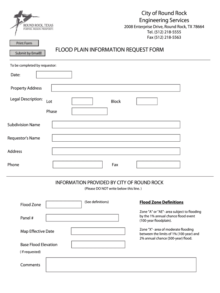
Case File No. I understand that it is my responsibility to determine the exact location of the flood plain inundation based on the requested information below.
This site uses cookies to enhance site navigation and personalize your experience.
By using this site you agree to our use of cookies as described in our Privacy Notice.
You can modify your selections by visiting our Cookie and Advertising Notice.... Read more...Read less