


Definition & Meaning
The DCRA zoning map is an essential tool designed for understanding zoning regulations and land use in Washington, D.C. It helps property owners, developers, architects, and city planners determine what types of buildings and land uses are allowed in different areas of the city. This map outlines the specific zoning districts assigned to each site, which dictates how property can be used and developed. It is crucial for any construction, renovation, or real estate project in the region to ensure compliance with the District of Columbia's zoning laws.
How to Use the DCRA Zoning Map
To effectively utilize the DCRA zoning map, you need to start by identifying the property in question. Enter the address into the map's search feature to locate the specific site's zoning district. The zoning map provides detailed information on zoning designations, each of which corresponds to a set of regulations governing building height, density, usage, and more. For example, a zoning district labeled "R-1" might designate a residential area with specific building codes, while "C-2" could signify a commercial zone with different standards. Understanding these distinctions is vital for planning any property developments or transactions.
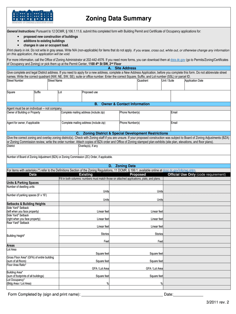
Steps to Complete the DCRA Zoning Data Summary Form
- Gather Property Information: Begin by obtaining the correct address, owner's details, and any previously issued permits related to the property.
- Identify Zoning District: Use the DCRA zoning map to determine the zoning district for the property.
- Detail Proposed Use: Clearly outline the proposed use or changes to the property, ensuring it aligns with the zoning district's regulations.
- Complete Mandatory Fields: Fill in all required fields, such as site address, zoning details, and contact information, ensuring accuracy.
- Review Submission Requirements: Verify any additional documentation needed for submission, such as floor plans or site surveys.
- Submit Form: Submit the form as part of your building permit or Certificate of Occupancy application according to DCRA guidelines.
Who Typically Uses the DCRA Zoning Map
The primary users of the DCRA zoning map include architects, developers, city planners, and real estate professionals. These individuals rely on accurate zoning information to guide their projects and ensure compliance with local regulations. Additionally, homeowners and prospective property buyers use this tool to understand the restrictions and opportunities associated with a specific location, aiding in informed decision-making regarding property investments or modifications.


Important Terms Related to the DCRA Zoning Map
- Zoning District: A specified area with distinct land use and building regulations.
- Floor Area Ratio (FAR): A metric that describes the relationship between the total building floor area and the size of the plot.
- Building Height Limits: Regulations controlling the maximum height a building can reach within a specific zoning district.
- Setback Requirements: Rules dictating the minimum distance buildings must be set back from the property line.
- Conditional Use: Land uses permitted under certain conditions within a zoning district.
Legal Use of the DCRA Zoning Map
The DCRA zoning map serves as an authoritative legal tool for interpreting and enforcing zoning laws within Washington, D.C. Adherence to zoning designations is mandatory for any development or construction activities. Failure to comply with zoning regulations can result in penalties, project delays, or the requirement to alter or cease construction plans. Legal use of this map ensures all parties involved in property development operate within the established guidelines, promoting orderly city growth and development.
Form Submission Methods (Online / Mail / In-Person)
The Zoning Data Summary form related to the DCRA zoning map can be submitted through various channels:
- Online: The most convenient method, allowing for digital submission via the DCRA's official portal. This method ensures faster processing and immediate confirmation of receipt.
- Mail: Physical forms can be mailed to DCRA offices. Be sure to include all necessary documents and allow for postal delays in processing times.
- In-Person: Direct submission at DCRA offices allows for immediate feedback and is suitable for detailed inquiries or additional services.
State-Specific Rules for the DCRA Zoning Map
As the DCRA zoning map is specific to Washington, D.C., it operates under unique regulations distinct from other states. The city's zoning laws reflect local priorities, such as historical preservation, urban density, and mixed-use development. Users must familiarize themselves with D.C.'s distinct zoning nomenclature and regulatory environment to ensure full compliance. Understanding these state-specific rules helps avoid common pitfalls and facilitates smoother project approval processes.
Key Elements of the DCRA Zoning Map
- Zoning Designations: Distinct codes indicating land use types.
- Overlay Zones: Additional provisions that may apply in specific areas, such as historic or transit zones.
- Zoning Administrator Decisions: Documentation of past rulings that can affect interpretations of zoning rules.
- Future Planning Areas: Insights into potential changes or developments under consideration, impacting long-term planning.