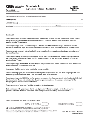
Get the up-to-date Geophysical Permit 2024 now

Get Form
Geophysical Permit Preview on Page 1

Here's how it works

01. Edit your form online
Type text, add images, blackout confidential details, add comments, highlights and more.
02. Sign it in a few clicks
Draw your signature, type it, upload its image, or use your mobile device as a signature pad.
03. Share your form with others
Send it via email, link, or fax. You can also download it, export it or print it out.

The fastest way to redact Geophysical Permit online

Form edit decoration
9.5
Ease of Setup
DocHub User Ratings on G2
9.0
Ease of Use
DocHub User Ratings on G2

Dochub is the best editor for updating your documents online. Adhere to this simple instruction to redact Geophysical Permit in PDF format online for free:

  1. Register and log in. Create a free account, set a strong password, and proceed with email verification to start managing your templates.
  2. Add a document. Click on New Document and choose the file importing option: upload Geophysical Permit from your device, the cloud, or a protected link.
  3. Make changes to the sample. Take advantage of the top and left-side panel tools to modify Geophysical Permit. Insert and customize text, images, and fillable areas, whiteout unneeded details, highlight the significant ones, and provide comments on your updates.
  4. Get your paperwork done. Send the sample to other people via email, generate a link for quicker file sharing, export the sample to the cloud, or save it on your device in the current version or with Audit Trail included.

Explore all the benefits of our editor right now!

be ready to get more

Complete this form in 5 minutes or less

Get form

Got questions?

We have answers to the most popular questions from our customers. If you can't find an answer to your question, please contact us.
Contact us
Geophysical survey is a broad term covering the suite of detection methods used to map contrasts between the physical properties of buried archaeological remains and the surrounding soil.
Technologies used for geophysical surveys include: Seismic methods, such as reflection seismology, seismic refraction, and seismic tomography. Seismoelectrical method. Geodesy and gravity techniques, including gravimetry and gravity gradiometry. Magnetic techniques, including aeromagnetic surveys and magnetometers.
Geophysical data is used to provide information on the physical properties of the Earths surface and subsurface. As a result, geophysical data can help locate hydrocarbons, minerals, aggregate, and other natural resources.
These methods are: Gravity method. Seismic method. Electromagnetic method. Geothermal method. Magnetic method. Electrical method. Radiometric method.
Common methods of acquiring geophysical data include borehole logging, surface-based, and cross-borehole methods. Borehole logging often provides the highest resolution information on materials immediately adjoining the borehole.
be ready to get more

Complete this form in 5 minutes or less

Get form

People also ask

3) How long do geophysical surveys take? Geophysical surveys can require anywhere from several hours to several weeks to complete depending upon the size of the area of interest, the depth of investigation, the geophysical method used, and the amount of survey coverage required.
Geophysical data is used to provide information on the physical properties of the Earths surface and subsurface. As a result, geophysical data can help locate hydrocarbons, minerals, aggregate, and other natural resources.
Geophysical surveys are performed from the soil surface, through boreholes, excavations or in a combination of placing sources and detectors. The survey scope, the method types and work techniques depend on the survey purpose, the available funds, the geological and topographic conditions.
The primary types of data held by the GSQ include: 2D and 3D seismic data. airborne geophysical data. gravity data. deep seismic reflection surveys. magnetotellurics (MT) surveys.
Geophysical surveys are performed from the soil surface, through boreholes, excavations or in a combination of placing sources and detectors. The survey scope, the method types and work techniques depend on the survey purpose, the available funds, the geological and topographic conditions.

Related links