


Definition and Meaning
The Soil Evaluation Report is a critical document used primarily to assess the suitability of soil for various purposes, including building construction, agricultural productivity, and environmental management. Typically issued by government agencies like the Wisconsin Department of Safety & Professional Services, this report captures essential data about the soil's physical and chemical properties. The information gathered includes soil texture, depth to limiting factors, and application rates. Understanding these parameters ensures that decisions regarding land use are informed and compliant with local regulations.
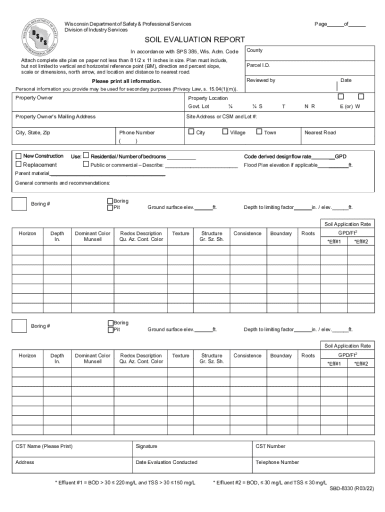
Key Elements of the Soil Evaluation Report
The Soil Evaluation Report comprises several critical sections, each designed to collect detailed information about the soil and related site specifications:
- Site Plan Specifications: Outlines the physical layout of the area under evaluation, identifying key landmarks and property boundaries.
- Soil Characteristics: Focuses on important parameters such as soil texture and depth to limiting factors, which impact the usability of the land.
- Application Rates: Details recommended application rates for various soil amendments based on current soil conditions.
- Property Details: Collects specific information about the location and size of the property, which is vital for contextual evaluation.
Each of these elements helps determine the land's suitability for specific purposes, ensuring compliance with regional construction and environmental guidelines.
Steps to Complete the Soil Evaluation Report
Filling out the Soil Evaluation Report requires attention to detail and a comprehensive understanding of both the site and soil characteristics:
- Gather Property Information: Begin by compiling all relevant property details, including size, location, and existing use.
- Conduct Soil Sampling: Engage a qualified professional to collect soil samples from various locations across the site to ensure a representative analysis.
- Perform Soil Analysis: Submit these samples for laboratory analysis to determine key attributes such as pH, texture, and organic matter content.
- Fill in Site Plan Specifications: Accurately depict site boundaries and any notable features on the site plan.
- Complete Soil Characteristics Section: Enter the laboratory results into the designated sections of the report, including depth to any limiting factors.
- Review and Finalize: Perform a thorough review to ensure all sections are complete and accurate before submission.
Legal Use of the Soil Evaluation Report
The Soil Evaluation Report is used to ensure compliance with legal standards and regulations concerning land use and building practices. In the United States, local and state authorities often require this report before approving construction permits. It serves as a legally binding document indicating that a site meets specific environmental and safety standards.
- Construction Permits: Required by local building authorities to ensure soil stability and environmental protection.
- Agricultural Use: Guides decisions on fertilizer application and crop rotation to optimize yield and soil health.
- Environmental Protection: Identifies potential contamination risks and necessary remediation efforts.
Who Typically Uses the Soil Evaluation Report
This document is widely utilized by various stakeholders involved in land management, construction, and environmental conservation:
- Builders and Developers: Use the report to assess site readiness for construction projects, ensuring compliance and safety.
- Environmental Consultants: Employ the report for impact assessments and environmental planning.
- Farmers and Agricultural Planners: Rely on soil evaluations to inform agricultural practices, such as crop selection and fertilization strategies.
- Government Agencies: Utilize the report for policy development and compliance monitoring.
Each of these users depends on the report’s detailed insights to make informed decisions that align with legal requirements and operational goals.


State-Specific Rules for the Soil Evaluation Report
While the general principles of soil evaluation are consistent across the United States, individual states may impose specific requirements:
- Wisconsin: Requires in-depth analysis of soil saturation and drainage capabilities due to local climatic conditions.
- California: Mandates soil corrosion risk assessment in regions prone to seismic activity to prevent infrastructure damage.
- Florida: Focuses on soil permeability and water table levels due to frequent flooding risks.
It is crucial for practitioners to be familiar with local regulations to ensure compliance and avoid potential legal and financial repercussions.
How to Obtain the Soil Evaluation Report
Securing a Soil Evaluation Report typically involves collaboration with professional services and government entities:
- Engage a Licensed Professional: Accredited engineers or soil scientists usually conduct the necessary soil tests and inspections.
- Contact Local Authorities: Depending on jurisdiction, local government offices can provide forms and guidance for completing the evaluation process.
- Request from Authorized Agencies: Some states or municipalities might offer standardized templates or forms online for public access.
Obtaining the report requires adherence to regulatory requirements and might involve fees for professional services and laboratory analyses.
Examples of Using the Soil Evaluation Report
Real-world applications of the Soil Evaluation Report demonstrate its versatility across different sectors:
- Home Construction: A developer planning a residential project uses the report to ascertain soil stability, ensuring foundations are secure.
- Agricultural Planning: A farmer evaluates soil nutrient levels to make informed decisions about crop rotation and fertilization practices.
- Infrastructure Development: Municipal engineers use soil reports to determine the suitability of road construction sites, ensuring durable roadbed conditions.
By illustrating these scenarios, it becomes evident how crucial these evaluations are in maintaining safety, efficiency, and environmental sustainability across multiple domains.