Garmin GPS Check-Out Form - Department of Geography and 2025

Get Form
Garmin GPS Check-Out Form - Department of Geography and Preview on Page 1

Here's how it works

01. Edit your form online
Type text, add images, blackout confidential details, add comments, highlights and more.
02. Sign it in a few clicks
Draw your signature, type it, upload its image, or use your mobile device as a signature pad.
03. Share your form with others
Send it via email, link, or fax. You can also download it, export it or print it out.

How to modify Garmin GPS Check-Out Form - Department of Geography and in PDF format online

Form edit decoration
9.5
Ease of Setup
DocHub User Ratings on G2
9.0
Ease of Use
DocHub User Ratings on G2

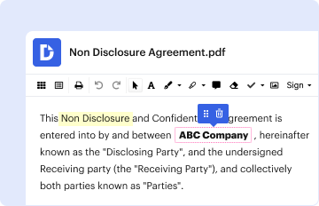
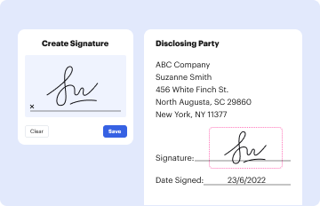
Adjusting documents with our comprehensive and user-friendly PDF editor is easy. Make the steps below to complete Garmin GPS Check-Out Form - Department of Geography and online quickly and easily:

  1. Sign in to your account. Sign up with your credentials or register a free account to test the service prior to choosing the subscription.
  2. Import a document. Drag and drop the file from your device or import it from other services, like Google Drive, OneDrive, Dropbox, or an external link.
  3. Edit Garmin GPS Check-Out Form - Department of Geography and. Quickly add and highlight text, insert pictures, checkmarks, and icons, drop new fillable fields, and rearrange or delete pages from your document.
  4. Get the Garmin GPS Check-Out Form - Department of Geography and accomplished. Download your adjusted document, export it to the cloud, print it from the editor, or share it with others via a Shareable link or as an email attachment.

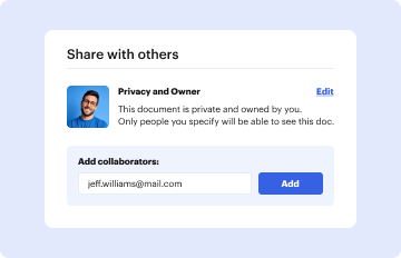
Make the most of DocHub, the most straightforward editor to promptly handle your documentation online!

be ready to get more

Complete this form in 5 minutes or less

Get form

Got questions?

We have answers to the most popular questions from our customers. If you can't find an answer to your question, please contact us.
Contact us
Select GPS Only to enable the GPS satellite system. Select GPS + GLONASS (Russian satellite system) for more accurate position information in situations with poor sky visibility. Select GPS + GALILEO (European Union satellite system) for more accurate position information in situations with poor sky visibility.
The only REAL thing you can do to improve accuracy is to turn your arm to that the clock face is always facing the sky. This will improve the GPS reception. Hi, My experience is about the same. Accuracy I get with Forerunner 230 or 235 in the right wrist for the same run is much better.
Format your coordinates in Google Maps Use decimal degrees in the following format: Correct: 41.40338, 2.17403. Incorrect: 41,40338, 2,17403.
The Garmin . img format is what Garmin devices use to store the maps for its GPS units. The img files contain a header and many subfiles. Imgs filestore is based on system.
Number of Satellites and Accuracy GPS currently has 31 operational satellites in its network, while GLONASS has 24, Galileo has 30, BeiDou has 35, and QZSS has 7. Due to the larger number of satellites, GNSS can provide more accurate location information than GPS alone.
be ready to get more

Complete this form in 5 minutes or less

Get form

People also ask

High Accuracy: Galileo is designed to provide very high accuracy, up to one meter for its commercial service, which is superior to that of GPS and GLONASS for civilian use.
The factory default of Garmin GPS devices is lat/long DM which means it is set to latitude and longitude in degrees and minutes, with decimal minutes. To change the position format on your Garmin GPS device, refer to your devices owners manual.
The default satellite system setting is Normal (GPS Only). The GPS + GLONASS or GPS + GALILEO options offer increased performance in challenging environments and faster position acquisition. Using GPS and another satellite together can reduce battery life more quickly than using GPS only.

Related links